AP Human Geography 1.1 – Flashcards
Unlock all answers in this set
Unlock answersquestion
Def: The system used to transfer locations from Earth's surface to a flat map. Sig: It will always cause distortion (direction, area, distance, shape and/or proximity.
answer
Projection
question
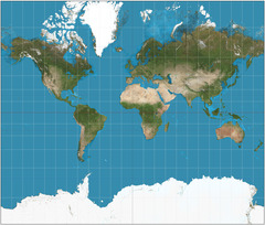
Def: Problems created when flattening the Earth (in terms of distance, direction, area, shape & proximity Ex: The Mercator Projection heavily distorts area at the higher latitudes.
answer
Distortion
question
Def: Size of something, refers to extent of an area being analyzed or discussed (local, global, etc.) Cartography: ratio of size of map to what it represents. Sig: Scales often interrelated (local affects global, vise versa) and vary (US is not wealthy but regions within are not.)
answer
Scale
question
Def: Generally, a map scale that shows a relatively large area on the ground with a low level of detail.
answer
Small Scale
question
Def: Generally, a map scale that shows a small area on the ground at a high level of detail.
answer
Large Scale
question
Def: A map where area is transformed based on a statistical factor (not true land area) Ex: A _____________ of the US would increase the size of cites and shrink the size of rural areas based on population
answer
Cartogram Map
question
Def: A thematic map in which a dot represents some frequency of the mapped variable Ex: Dots represented cholera deaths were placed on a map to show they clustered around specific infected water wells
answer
Dot Map
question
Def: A thematic map where parts of the map are shaded differently based on a variable. Ex: The US red + blue map correspond based on whether states voted Republican or Democrat.
answer
Choropleth Map
question
Def: A thematic map with lines that connect points of equal value. Ex: A topographic map uses lines to reflect changing elevation.
answer
Isoline Map
question
Def: A thematic map in which the size of a symbol varies in proportion to the frequency of intensity of the mapped varibable
answer
Proportional (Graduated) Symbol Map
question
Def: A computer system that collects, stores, retrieves, and depicts spatial data form the real world. Ex: Google Maps
answer
Geographic Information System (GIS)
question
Def: An example of a "satellite navigation system", helps determine absolute location
answer
Global Positioning System (GPS)
question
Def: The Scanning of Earth's surface by satellite or a high-flying plane to obtain information Ex: See urban sprawl, shrinking ice caps, and deforestation
answer
Remote Sensing
question
Geospatial, Qualitative, Quantitative
answer
Data
question
Show land forms, represent Earth's terrain
answer
Physical Map
question
"Map" distinct peoples' tangible and intangible cultural assets within local landscapes around the world.
answer
Cultural Map
question
Map especially designed to show a particular theme connected with a specific geographic area. These maps can portray physical, social, political, cultural, economic, sociological, agricultural, or any other aspects of a city, state, region, nation, or continent"
answer
Thematic Map
question
Little distortion but size at poles are greatly distorted

answer
Mercator Projection
question
Good across oceans but land masses smaller
answer
Robinson Projection
question
Shows Earth's landmasses without interruption, rendered by juxtaposing a grid of triangles on the globe and transferring the data to corresponding triangles
answer
Dymaxion Projection
question
Def: The science or practice of drawing maps.
answer
Cartography
question
Def: A group, body, or mass composed of many distinct parts.
answer
Aggregation


