Ap Human Geography Unit 1 Answers – Flashcards
Unlock all answers in this set
Unlock answersquestion
Natural features and processes. Ex. Mountains
answer
Physical Geography
question
How human activity affects/is influenced by the Earth's surface.
answer
Human Geography
question
Grouping of regions that have common characteristics Ex. Middle East = Islamic
answer
Regional Geography
question
What've we done to the environment (often negative) Ex. Fracking
answer
Environmental Geography
question
Fashioning of a natural landscape by a cultural group. Ex. Football fields are found here because football is important to us.
answer
Cultural Landscape
question
The science of mapmaking
answer
Cartography
question
A 2D, or flat, representation of Earth's surface or a portion of it
answer
Map
question
To be a Reference Tool - find locations & Communication Tool - show geographic info.
answer
What's the purpose of a map?
question
Reference map - location and navigation & Thematic map - displaying variables
answer
What are the two types of maps?
question
Was the first to use the word "geography" and determined the circumference of the Earth. TIME: Greek
answer
Eratosthenes
question
Was the first to produce a world map. TIME: Age of Exploration
answer
Geradus Mercator
question
Was the first to describe the relationship between Man and Nature. TIME: Modern
answer
George Perkins Marsh
question
Created the concept of cultural landscapes, and argued that it should be the main focus of geography. TIME: Modern
answer
Carl Sauer
question
The relationship between a map's distance and the actual distance on Earth.
answer
Scale
question
Large scale = Small area Ex. School map
answer
Large Scale
question
Small scale = Large area Ex. World map
answer
Small Scale
question
Remember the smaller the fraction the larger the area. (Inversely Related)
answer
What do you have to essentially remember about large and small scale maps?
question
Fraction/Ratio (numbers), Written (statements), Graphic Bar(image)
answer
What are the three types of scales?
question
Small scale (large area) maps
answer
When is distortion greatest?
question
The scientific method of transferring locations on Earth to a flat map
answer
Map projection
question
Distortion (They all lie)
answer
What do all maps have?
question
Shape - appearance, Distance, Relative size - one area may appear larger than the other, Direction
answer
Types of distortion
question
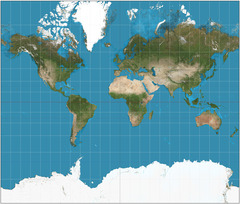
Used for direction, distorted near poles

answer
Mercator Projection
question
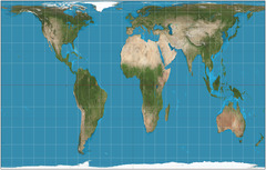
Shows accurate sizes of landmasses, distortion near equator

answer
Peters Projection
question
Cylindrical, old school. Only prime meridian & parallels are straight
answer
Mollweide Projection
question
Minimal error. Good for oceans. Land areas are smaller.
answer
Robinsons Projection
question
Shows map of the poles
answer
Azimuthal (Planar) Projection
question
Bad for navigation, good for data
answer
Interrupted Projection (Goodes-Homosoline)
question
(Rare) Most accurate of landmasses
answer
Fullers Projection
question
Exact position of something, measured with the GPS
answer
Absolute Location
question
Meridians. Vertical lines.
answer
Longitude
question
Parallels. Horizontal lines.
answer
Latitude
question
The central meridian at 0 degrees
answer
Prime meridian
question
Longitude. 360 degrees / 24 = 15, meaning every 15 degrees east/west is a new time zone. (East clock ahead, West backward)
answer
How do you tell time: with longitude or latitude?
question
Shows general info about climate & precipitation
answer
Climate Map
question
Shows types of natural resources or economic activity
answer
Economic Map
question
Shows physical features

answer
Physical Map
question
Shows political boundaries
answer
Political map
question
Shows roads
answer
Road Map
question
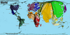
Shows statistics in a pictorial way.

answer
Cartogram Map
question
Shows elevation changes. The lines are called contour/isoline. The closer the lines the steeper it is. (Ex. Hikers use this)
answer
Topographic Map
question
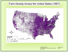
Shows the frequency of something using dots

answer
Dot Map
question
Shows data using colors/tonal shadings (More = Darker)
answer
Choropleth Map
question
Shows movement using arrows
answer
Flow-line Map
question
Your perception of a place
answer
Cognitive or Mental Map
question
A system that pinpoints the exact location of something using satellites, tracking stations, and receivers
answer
Global Position System (GPS)
question
A computer that stores, organizes, analyzes, and displays geographic data. Used for thematic layers.
answer
Geographic Information System (GIS)
question
The collection of data about Earth's surface using a satellite or other long-distance methods
answer
Remote Sensing


